
- ABOUT US
- PROGRAM AREAS
- CONSERVATION APPROACH
- EDUCATION
- MULTIMEDIA
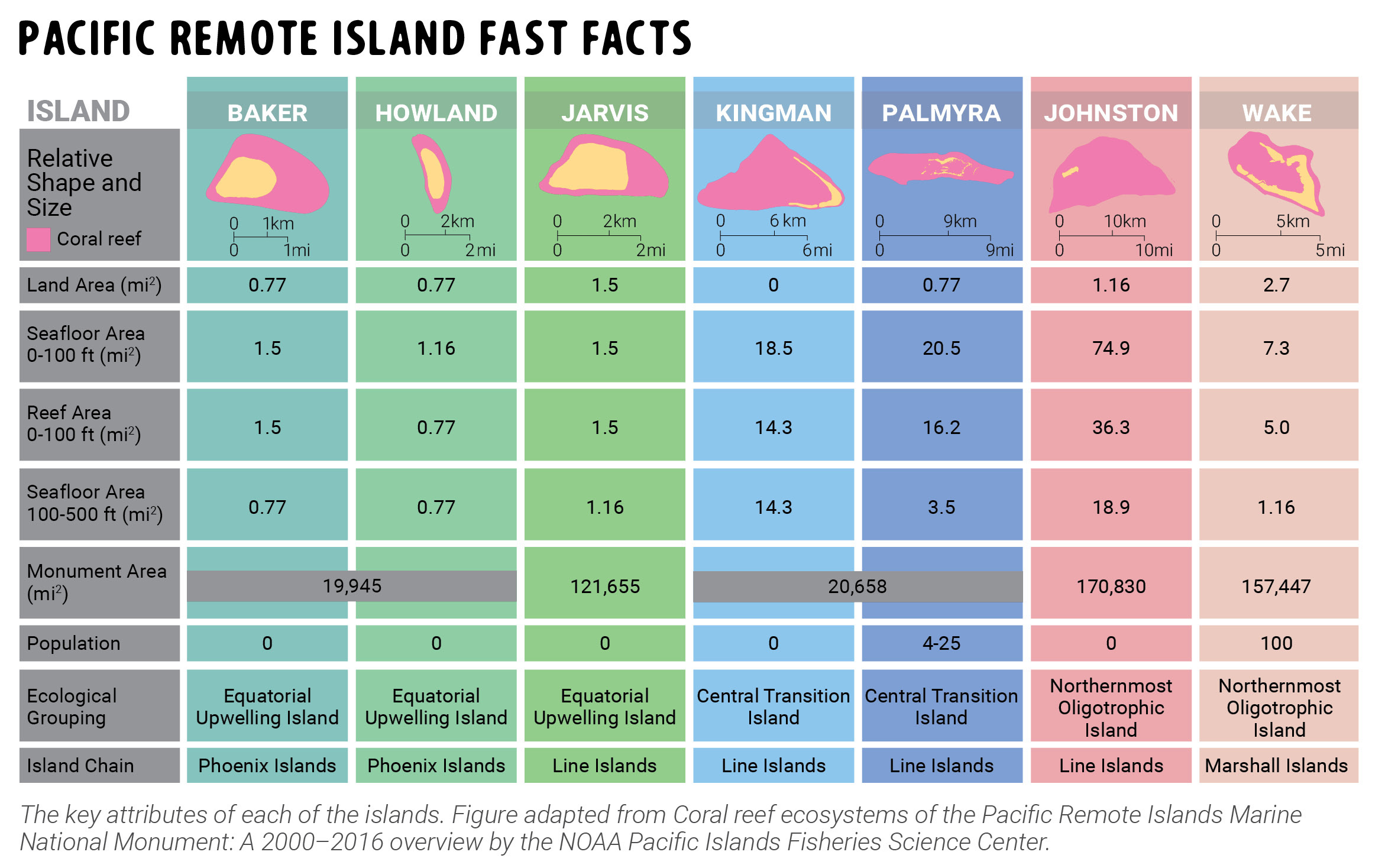
Pacific Remote Island Fast Facts
This infographic describes key attributes and geographic features of the Pacific Remote Islands.
This infographic was made in collaboration with the University of Maryland Center for Environmental Science Integration and Application Network and adapted from the Pacific Remote Islands Marine National Monument: A 2000-2016 overview by the NOAA Pacific Islands Fisheries Science Center.
Visit the National Coral Reef Monitoring Program's page for all U.S. coral reef status reports.
Infographic Transcript: Pacific Remote Island Fast Facts
Baker Island has a land area of 0.77 square miles, a seafloor area from 0-100 ft of 1.5 square miles, a reef area from 0-100 ft of 1.5 square miles, a seafloor area of 100-500 ft of 0.77 square miles. The monument area of Baker and Howland is 19,945 square miles. The population of Baker Island is zero, the ecological grouping is Equatorial Upwelling Island, and the Island Chain is the Phoenix Islands.
Howland Island has a land area of 0.77 square miles, a seafloor area from 0-100 ft of 1.16 square miles, a reef area from 0-100 ft of 0.77 square miles, a seafloor area of 100-500 ft of 0.77 square miles. The monument area of Baker and Howland is 19,945 square miles. The population of Howland Island is zero, the ecological grouping is Equatorial Upwelling Island, and the Island Chain is the Phoenix Islands.
Jarvis Island has a land area of 1.5 square miles, a seafloor area from 0-100 ft of 1.5 square miles, a reef area from 0-100 ft of 1.5 square miles, a seafloor area of 100-500 ft of 1.16 square miles. The monument area is 121,655 square miles. The population of Jarivs Island is zero, the ecological grouping is Equatorial Upwelling Island, and the Island Chain is the Line Islands.
Kingman Reef has a land area of 0.77 square miles, a seafloor area from 0-100 ft of 18.5 square miles, a reef area from 0-100 ft of 14.3 square miles, a seafloor area of 100-500 ft of 14.3 square miles. The monument area of Kingman Reef and Palmyra Atoll is 20,658 square miles. The population of Kingman Reef is zero, the ecological grouping is Central Transition Island, and the Island Chain is the Line Islands.
Palmyra Atoll has a land area of 0 square miles, a seafloor area from 0-100 ft of 20.5 square miles, a reef area from 0-100 ft of 16.2 square miles, a seafloor area of 100-500 ft of 3.5 square miles. The monument area of Kingman Reef and Palmyra Atoll is 20,658 square miles. The population of Palmyra Atoll is 4 to 25, the ecological grouping is Central Transition Island, and the Island Chain is the Line Islands.
Johnston Atoll has a land area of 1.16 square miles, a seafloor area from 0-100 ft of 74.9 square miles, a reef area from 0-100 ft of 36.3 square miles, a seafloor area of 100-500 ft of 18.9 square miles. The monument area is 170,830 square miles. The population of Johnston Atoll is zero, the ecological grouping is Northernmost Oligotrophic Island, and the Island Chain is the Line Islands.
Wake Island has a land area of 2.7 square miles, a seafloor area from 0-100 ft of 7.3 square miles, a reef area from 0-100 ft of 5.0 square miles, a seafloor area of 100-500 ft of 1.16 square miles. The monument area is 157,447 square miles. The population of Wake Island is 100, the ecological grouping is Northernmost Oligotrophic Island, and the Island Chain is the Marshall Islands.
About Us

The NOAA Coral Reef Conservation Program was established in 2000 by the Coral Reef Conservation Act. Headquartered in Silver Spring, Maryland, the program is part of NOAA's Office for Coastal Management.
The Coral Reef Information System (CoRIS) is the program's information portal that provides access to NOAA coral reef data and products.
Work With US
U.S. Coral Reef Task Force
Funding Opportunities
Employment
Fellowship Program
Contracting Assistance
Graphic Identifier
Featured Stories Archive
Access the archive of featured stories here...
Feedback
Thank you for visiting NOAA’s Coral Reef Conservation Program online. Please take our website satisfaction survey. We welcome your ideas, comments, and feedback. Questions? Email coralreef@noaa.gov.
Stay Connected
Contact Us
NOAA’s Coral Reef Conservation Program
SSMC4, 10th Floor
1305 East West Highway
Silver Spring, MD 20910
coralreef@noaa.gov